 New York Public Library
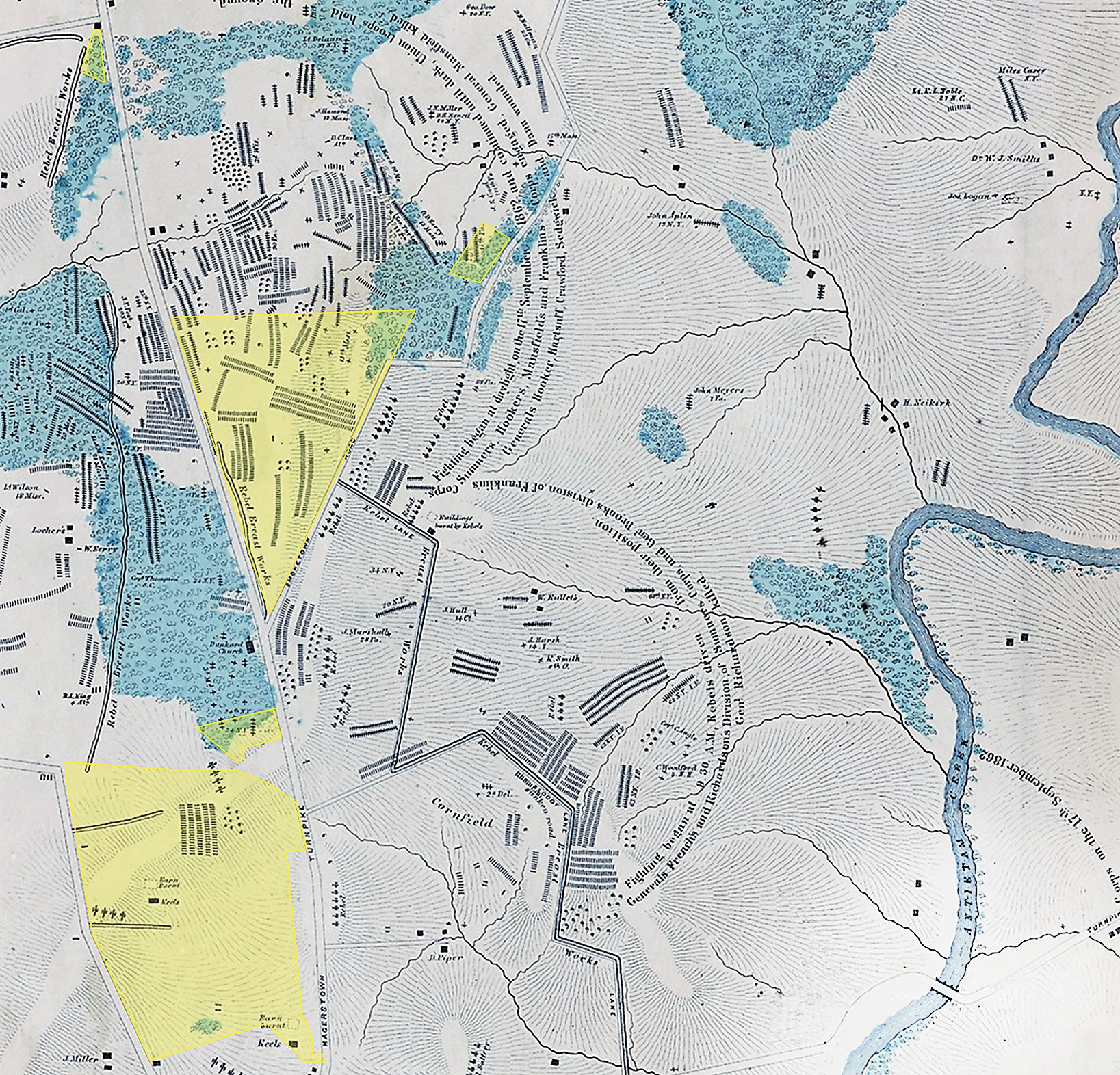
Using S.G. Elliott’s Burial Map as a base, this illustration highlights the properties preserved by the Trust on the Antietam Battlefield, which saw an estimated 673 battlefield burials.
This summer, a map found in a New York Public Library collection caused quite a stir. Created in 1864 by S.G. Elliott, well known for his similar mapping at the Gettysburg battlefield, it shows precise locations of more than 5,800 burials after the September 17, 1862, Battle of Antietam. Historians were eager to explore the interpretive opportunities created by such a resource—particularly its interplay with other primary sources such as diary entries, photographs, and more. Not just a powerful visual illustration of the human cost of war, the Elliott Burial Map is also a tool for shaping preservation efforts at Antietam, like its sister document does for Gettysburg.
Historians know that the site of death in battle and the place of burial are often nearly the same. The fallen were interred by their comrades or by burial crews. Manpower and time dictated that bodies may have been grouped in a row or cluster, but typically were not moved far.
So the Elliott Burial Map can function almost as a “heat map” for Antietam. Rather than relying on interpretations of period accounts, we now have data plotted onto the landscape. Muster rolls may have told us how many men from a given regiment died in the battle, and reports, letters, and diaries might have indicated that a significant number fell during a particular volley—perhaps offering some kind of reference point, like “halfway across the field.” But here we have practical data indicating where events occurred.
The manner in which Antietam National Battlefield was envisioned and created makes this map especially valuable. Unlike with other early battlefield parks at Gettysburg, Chickamauga, or Shiloh, the federal government did not intend to acquire large holdings at Antietam. Instead it focused on creating a road system designed to teach military strategy by using the battlefields as classrooms, a purpose for which only rights of way were required. The work of protecting large swaths of the battlefield was, it turned out, left to 20th-century preservationists.
One of the first things Trust historians did upon seeing the Elliott Burial Map was to overlay imagery to locate the properties we have protected at Antietam to date—and we were pleased with this verification of our targeting. Of the 5,800 burials recorded on the map, more than 600 took place on the 461 acres the Trust has helped save. We then looked at a 2.6-acre tract near the Dunker Church that we were at that moment evaluating. Needless to say, its acquisition passed muster; you can visit battlefields.org to contribute to its preservation.
O. James Lighthizer is president of the nonprofit, nonpartisan American Battlefield Trust, which is dedicated to preserving America’s hallowed battlegrounds—Revolutionary War, War of 1812, and Civil War—and educating the public about their significance.